Using 3D Mapping to Plan More Sustainable Cities
For the first time large and complex 3D multi-level pedestrian-built environment like Sheung Wan to Wan Chai in Hong Kong are amenable to walkability predictive analysis.

3D indoor and outdoor pedestrian paths from Sheung Wan to Admiralty, the world most complex and dense 3D built environment
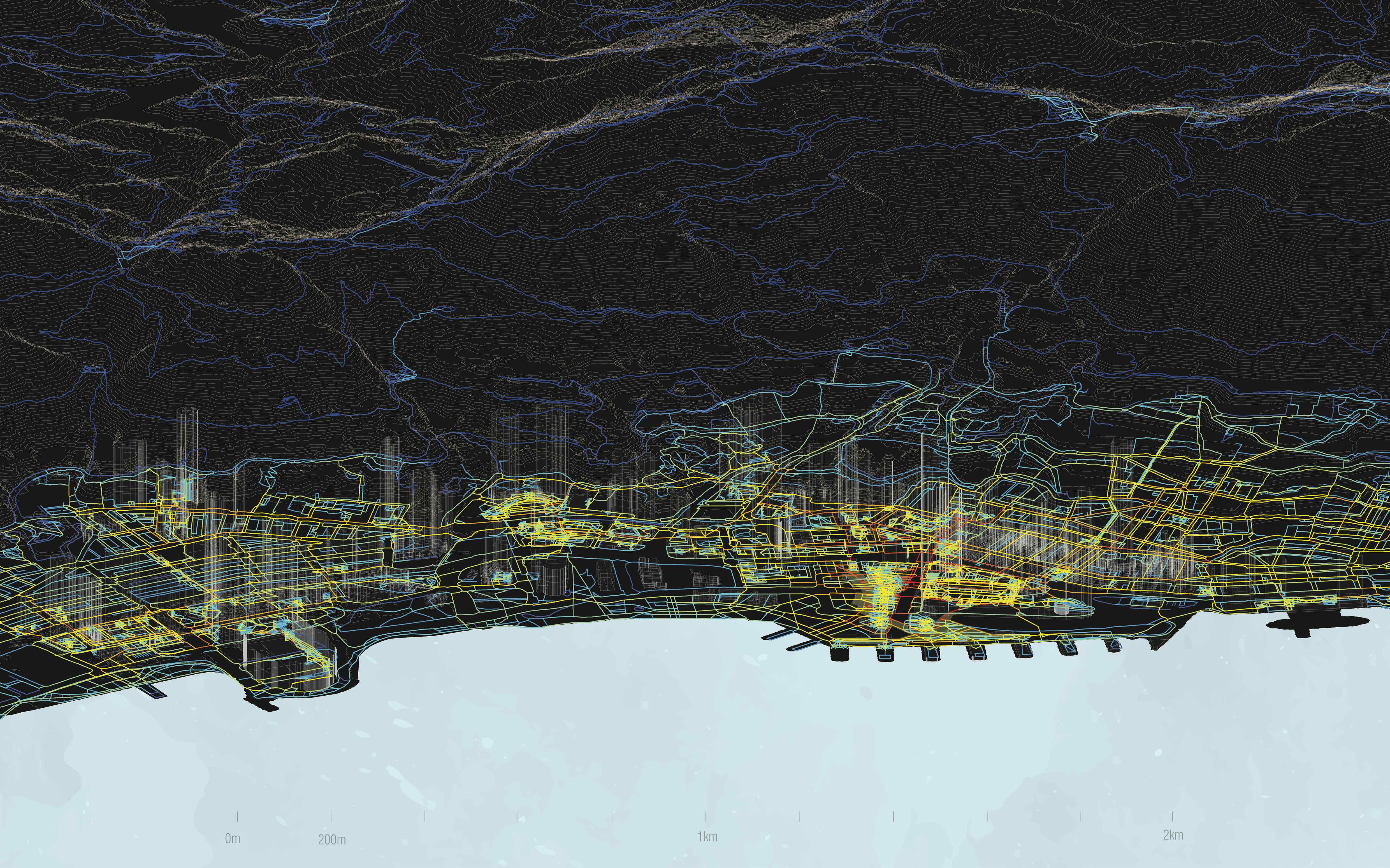
sDNA 3D analysis of the government proposal for the Harbourfront masterplan (from Sheung Wan to Admiralty), showing 3D indoor and outdoor principal pedestrian paths (principal in red and orange to secondary yellow and minor in green and blue tones)
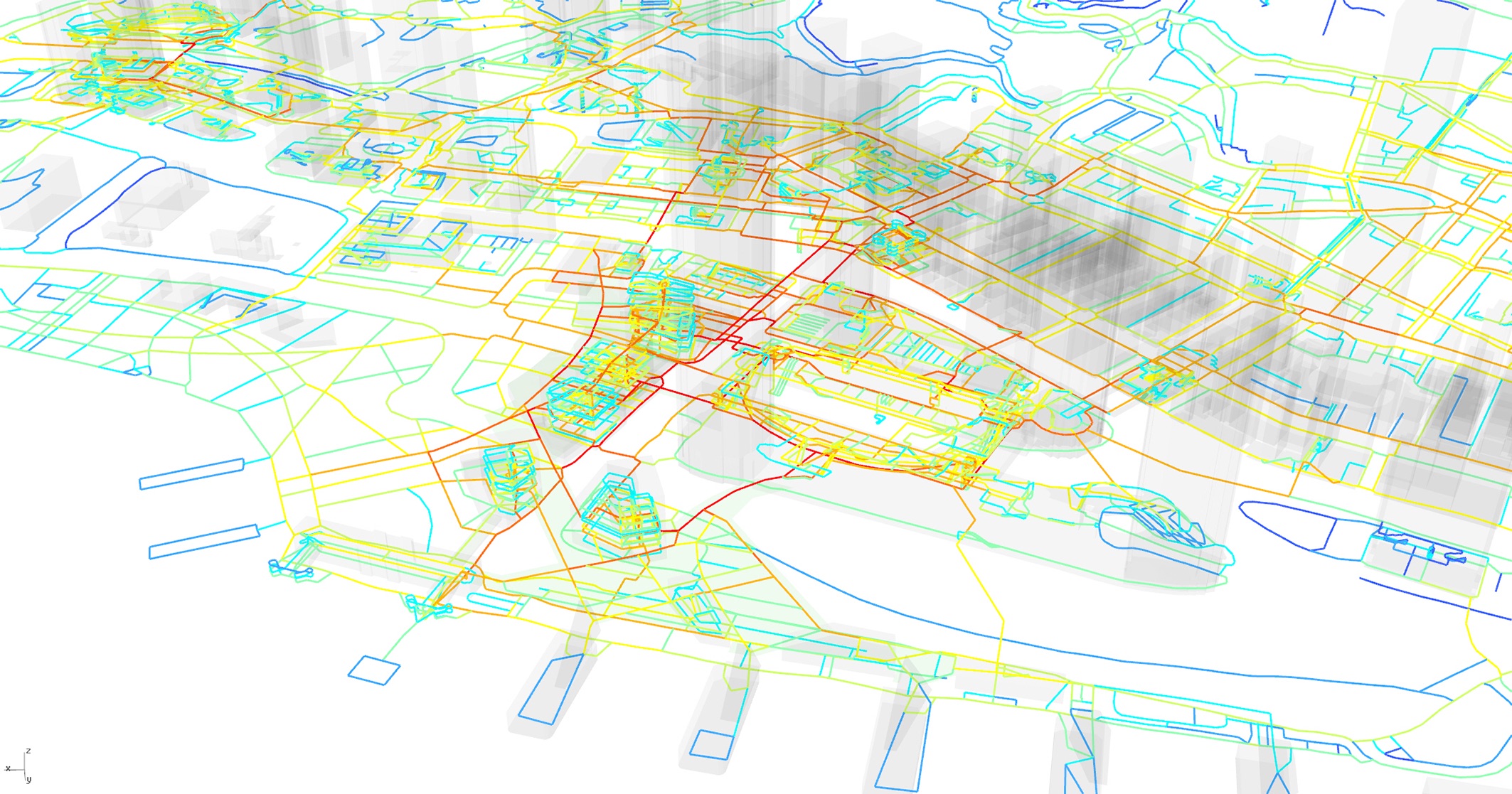
sDNA 3D analysis of the government proposal for the Harbourfront masterplan (IFC area focus), showing 3D indoor and outdoor principal pedestrian paths from red to blue
![Mr Alain Chiaradia (left) and Mr Paul Zimmerman, Board Member of Civic Exchange, discussing the 3D pedestrian network map created by the Spatial Design Network Analysis (sDNA) [Photo from KE Video “Making Our City More Walkable for All” (https://www.ke.hku.hk/story/video/making-our-city-more-walkable-for-all)]](/f/story/1061/2.png)
Mr Alain Chiaradia (left) and Mr Paul Zimmerman, Board Member of Civic Exchange, discussing the 3D pedestrian network map created by the Spatial Design Network Analysis (sDNA) [Photo from KE Video “Making Our City More Walkable for All” (https://www.ke.hku.hk/story/video/making-our-city-more-walkable-for-all)]
Unlike most other major cities of the world, Hong Kong is a city built on a hill.
“Everything we know about cities that are flat doesn’t apply to cities that are not flat,” explained Mr Alain Chiaradia, Associate Professor of the Department of Urban Planning and Design.
Hong Kong’s cityscape poses problems for city planners seeking to understand how people use the city’s space and find ways to make movement easier, for instance, by increasing access for those in wheelchairs and pushchairs, or tourists with suitcases. City planners can also plan better cities by having a tool that enables them to visualise the position and impact of planned new buildings on people’s movements. Those patterns of movements affect housing, health, wellbeing, social life, business opportunities, land values and the wider economy.
As well as being positioned on an uneven ground, Hong Kong has many tall skyscrapers and a setting between water and hills in a sub-tropical climate with typhoon unlike Singapore. In addition, about 90 per cent of the Hong Kong’s population travels regularly on public transport. They do so using a complex series of networks that are located both overland and underground as well as along the raised pedestrian walkways that crisscross the different urban districts.
While studying major cities including New York, London, Paris, Shenzhen, Shanghai and Tokyo, Mr Chiaradia realised the need for a 3D model to analyse dense complex multi-level cityscapes like Hong Kong to improve city planning and sustainability. He and his team developed the Spatial Design Network Analysis (sDNA) software to analyse 3D pedestrian network map based on network science that embed human spatial navigation cognition features that enables better evidence-based urban planning and design across disciplines. With a comprehensive 3D pedestrian network map of a city, city planners, professionals and communities can assess and compare the efficacy of 2D or 3D networks for any kind of movement – walking, cycling, road or rail. This helps them create plans that are specific to each neighbourhood’s needs and characteristics. Up to 5 million dwellers in these cities may have already benefitted from well-planned walkable alternatives to car use.
In Hong Kong, the city’s waterfront masterplan is already using sDNA to ensure that all its parts will fit together usefully and well. The Lands Department of the HKSAR Government who bought the pedestrian network map from the Faculty of Architecture is providing more information to enhance the data available for analysis. The results will be available on open data within a year and 3D maps of the city could soon be available as a downloadable app to help pedestrians find their way through the city. For the first time the large and complex 3D multi-level pedestrian-built environment of Hong Kong will be amenable to walkability predictive analysis.
As well as enabling better planning for the city, sDNA can also help identify ways to encourage people to walk more, and to enjoy walking more, in a boost to the population’s health. In consideration of the Hong Kong’s ageing society, Mr Chiaradia expected that city planning would also be about making old age more enjoyable.
Mr Alain Chiaradia and his team members, Professor Christopher John Webster, Dr Guibo Sun and Dr Chinmoy Sarkar of Department of Urban Planning and Design, received the Faculty Knowledge Exchange Award 2019 of the Faculty of Architecture for the project ‘Spatial Design Network Analysis (sDNA) Improving Evidence-based Urban Planning and Design across Discipline Nationally and Worldwide’.